BC HighwayCams - Highway 37
Northern, Southern Interior and Vancouver Island images will update every 15 to 30 minutes; Lower Mainland images will update about every two to 15 minutes.
Please note all BC HwyCams use Pacific Time Zone (PT).
Attention motorists:
Spring weather can make highway conditions in B.C. unpredictable, particularly through high mountain passes. Please be prepared and be aware that winter tires and chains may still be needed.
This highway cam image is currently unavailable due to technical difficulties. Our technicians have been alerted and service will resume as soon as possible. |
|
|||||||
|
||||||||
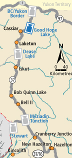
Image Temporarily Unavailable. BC-Yukon Border Hwy 37 at BC-Yukon Border. | Image Temporarily Unavailable. Good Hope Lake Hwy 37 near Good Hope Lake, looking north. |  Dease Lake Junction of Hwy 37 and Commercial Drive in Dease Lake, looking north on Hwy 37. |  Meziadin Junction Hwy 37 and Hwy 37A at Meziadin Junction, looking north. | |||||
 Gitanyow - N Hwy 37N at Kitwancool Access Rd about 2.5 km south of Gitanyow and 21 km north of Hwy 16 junction, looking north. |  Gitanyow - S Hwy 37N at Kitwancool Access Rd about 2.5 km south of Gitanyow and 21 km north of Hwy 16 junction, looking south. |  Onion Lake Hwy 37S at Onion Lake Cross Country ski trails, looking north. |  Kitimat Hwy 37 at Oolichan Avenue, 5 km north of Kitimat, looking North | |||||