BC HighwayCams - Highway 97 (Southern Interior Region)
Northern, Southern Interior and Vancouver Island images will update every 15 to 30 minutes; Lower Mainland images will update about every two to 15 minutes.
Please note all BC HwyCams use Pacific Time Zone (PT).
Attention motorists:
Spring weather can make highway conditions in B.C. unpredictable, particularly through high mountain passes. Please be prepared and be aware that winter tires and chains may still be needed.
 |
|
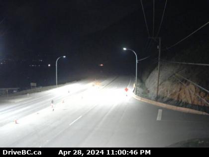
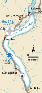
| Callan Rd
Hwy 97 at Callan Rd, about 6 km north of Summerland, about 15 km south of Peachland. Looking south. (elevation: 451 metres) |
|
|
|
|
Weather Forecast (from Environment Canada) |
 |
| Hixon
Hwy 97 at Swanson Road near Hixon, looking north. | Hush Lake - N
Hwy 97, about 25 km north of Quesnel near Hush Lake Rd, looking north. | Hush Lake - S
Hwy 97, about 25 km north of Quesnel near Hush Lake Rd, looking south. | Dragon Lake - N
Hwy 97, at Sales Rd, about 10 km south of Quesnel, looking north. | Dragon Lake - W
Hwy 97, at Sales Rd, about 10 km south of Quesnel, looking west. | Dragon Lake - E
Hwy 97, at Sales Rd, about 10 km south of Quesnel, looking east. | Dragon Lake - S
Hwy 97, at Sales Rd, about 10 km south of Quesnel, looking south. | McLeese Lake - W
Hwy 97 and Beaver Lake Rd junction north of McLeese Lake, looking west. | McLeese Lake - SE
Hwy 97 and Beaver Lake Rd junction north of McLeese Lake, looking southeast. | McLeese Lake - S
Hwy 97 and Beaver Lake Rd junction north of McLeese Lake, looking south. | Bull Mountain - N
Hwy 97, north of Williams Lake near the turn off to the Bull Mountain ski area, looking north. | Bull Mountain - S
Hwy 97, north of Williams Lake near the turn off to the Bull Mountain ski area, looking south, | Enterprise - N
Hwy 97, 37 km south of Williams Lake, looking north. | Enterprise - S
Hwy 97, 37 km south of Williams Lake, looking south. | Begbie Summit
Hwy 97, at Lookout Road near Begbie Summit, about 21 km south of 100 Mile House, looking north. | Big Bar
Hwy 97, 8 km north of Clinton just before Big Bar rest area, looking north. | Monte Creek Brake Check - N
Hwy 97 at the Monte Creek brake check, looking north. | Monte Creek Brake Check - S
Hwy 97 at the Monte Creek brake check, looking south. | Falkland
Hwy 97 at Silvernails Road near Falkland, looking southeast. | Kalamalka Lookout
Hwy 97 at Vista Road turnoff south of Vernon, looking north. | Lake Country - N
Hwy 97, in Lake Country, by Wood Lake, looking north. | Lake Country - S
Hwy 97, in Lake Country, by Wood Lake, looking south. | Kelowna
Hwy 97 at Hwy 33 in Kelowna, looking North on Hwy 97. | WR Bennett Bridge 02
West end of WR Bennett Bridge connecting Kelowna and West Kelowna, looking west. | WR Bennett Bridge 04
Mid span of WR Bennett Bridge connecting Kelowna and West Kelowna, looking west. | WR Bennett Bridge 07
East end of WR Bennett Bridge connecting Kelowna and West Kelowna, looking west. | WR Bennett Bridge 11
East approach to WR Bennett Bridge at Abbott Street, looking west along Hwy 97. | Hwy 97 at Hwy 97C - N
Hwy 97 at Hwy 97C junction, about 5 km south of Westbank, looking north. | Hwy 97 at Hwy 97C - W
Hwy 97 at Hwy 97C junction, about 5 km south of Westbank, looking west. | Hwy 97 at Hwy 97C - E
Hwy 97 at Hwy 97C junction, about 5 km south of Westbank, looking east. | Hwy 97 at Hwy 97C - S
Hwy 97 at Hwy 97C junction, about 5 km south of Westbank, looking south. | Callan Rd
Hwy 97 at Callan Rd, about 6 km north of Summerland, about 15 km south of Peachland. Looking south. | Kaleden - N
Hwy 97 at Hwy 3A junction, just south of Kaleden Weigh Scale, looking north. | Kaleden - W
Hwy 97 at Hwy 3A junction, just south of Kaleden Weigh Scale, looking west. | Kaleden - S
Hwy 97 at Hwy 3A junction, just south of Kaleden Weigh Scale, looking south. |
|