BC HighwayCams - Highway 1 (Trans Canada Highway)
Northern, Southern Interior and Vancouver Island images will update every 15 to 30 minutes; Lower Mainland images will update about every two to 15 minutes.
Please note all BC HwyCams use Pacific Time Zone (PT).
Attention motorists:
Spring weather can make highway conditions in B.C. unpredictable, particularly through high mountain passes. Please be prepared and be aware that winter tires and chains may still be needed.
 |
|
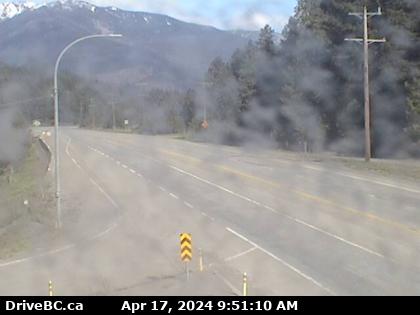
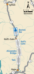
| Boston Bar - N
Hwy 1 at Kahmoose Rd in Boothroyd, 12 km north of Boston Bar, looking north. (elevation: 285 metres) |
|
|
|
|
Weather Forecast (from Environment Canada) |
 |
| Yale - N
Hwy 1, at Victoria Street in Yale, looking northbound. | Yale - S
Hwy 1, at Victoria Street in Yale, looking southbound. | Alexandra Bridge - N
Hwy 1 at Alexandra Bridge, looking north. | Alexandra Bridge - S
Hwy 1 at Alexandra Bridge, looking south. | Hells Gate - N
Hwy 1 at Bradley Hill, about 3.5 km south of Hells Gate, looking north. | Hells Gate - S
Hwy 1 at Bradley Hill, about 3.5 km south of Hells Gate, looking south. | Boston Bar - N
Hwy 1 at Kahmoose Rd in Boothroyd, 12 km north of Boston Bar, looking north. | Boston Bar - S
Hwy 1 at Kahmoose Rd in Boothroyd, 12 km north of Boston Bar, looking south. | Gladwin - W
Hwy 1, about 6 km east of Lytton Airport, looking west. | Gladwin - E
Hwy 1, 6 km east of Lytton Airport, looking east. | Spences Bridge
Hwy 1, on the west side of the Thompson River at the north end of Spences Bridge, looking north. | Cache Creek
Hwy 1 at Collins Rd, looking east on Hwy 1/97. | Savona
Hwy 1 at Holloway Drive, near Savona, looking west. | Dufferin - W
Hwy 1 in Kamloops, east of Copperhead Drive, looking west. | Dufferin - E
Hwy 1 in Kamloops, east of Copperhead Drive, looking east. | Kamloops - W
Hwy 1 at Peterson Creek bridge in Kamloops, looking west. | Kamloops - E
Hwy 1 at Peterson Creek bridge in Kamloops, looking east. | Miners Bluff - W
Hwy 1, between Monte Creek and Pritchard, looking west. | Miners Bluff - E
Hwy 1, between Monte Creek and Pritchard, looking east. | Squilax - W
Hwy 1, east of Squilax Bridge, looking west. | Squilax - E
Hwy 1, east of Squilax Bridge, looking east. | Adams Lake West Ferry Lineup
Adams Lake Ferry west shore landing, looking at ferry line up toward Rawson Road. | Adams Lake West Ferry Landing
Adams Lake Ferry west shore landing, looking at ferry landing on west side of lake. | Adams Lake East Ferry Landing
Adams Lake Ferry east shore landing, looking at ferry landing on east side. | Sorrento - Blind Bay
Hwy 1, at Highland Drive east of Sorrento at the Blind Bay turn off, looking southeast. | Salmon Arm - N
Hwy 1 at 30th Street SW in Salmon Arm, looking north. | Salmon Arm - W
Hwy 1 at 30th Street SW in Salmon Arm, looking west. | Salmon Arm - E
Hwy 1 at 30th Street SW in Salmon Arm, looking east. | Salmon Arm - S
Hwy 1 at 30th Street SW in Salmon Arm, looking south. | Annis Pit - W
Hwy 1 at Annis Pit, 8 km southwest of Sicamous, looking west. | Annis Pit - E
Hwy 1 at Annis Pit, 8 km southwest of Sicamous, looking east. | Sicamous - W
Hwy 1, east of Sicamous at Cambie/Solsqua Roads, looking west. | Sicamous - E
Hwy 1, east of Sicamous at Cambie/Solsqua Roads, looking east. | Perry River - W
Hwy 1 near Perry River Bridge, about 30 km east of Sicamous, looking west. | Perry River - E
Hwy 1 near the Perry River Bridge, about 30 km east of Sicamous, looking east. | Eagle River - W
Hwy 1, about 33 km west of Revelstoke, looking west. | Eagle River - E
Hwy 1, about 33 km west of Revelstoke, looking east. | Griffin Lake - W
Hwy 1, by Griffin Lake, about 27 km west of Revelstoke, looking west. | Griffin Lake - E
Hwy 1, by Griffin Lake, about 27 km west of Revelstoke, looking east. | Three Valley Gap - W
Hwy 1, near Three Valley Gap, about 20 km west of Revelstoke, looking west. | Three Valley Gap - E
Hwy 1, near Three Valley Gap, about 20 km west of Revelstoke, looking east. | Clanwilliam Railway Overpass - W
Hwy 1, west of Revelstoke, looking west. | Clanwilliam Railway Overpass - E
Hwy 1, west of Revelstoke, looking east. | Boulder Hill - W
Hwy 1, about 7 km west of Revelstoke, looking west. | Boulder Hill - E
Hwy 1, about 7 km west of Revelstoke, looking east. | One-Mile Hill - W
Hwy 1, about 4 km west of Revelstoke, looking west. | One-Mile Hill - E
Hwy 1, about 4 km west of Revelstoke, looking east. | Hwy 1 at Hwy 23 - N
Hwy 1 at Hwy 23 in Revelstoke, looking north to Westside Road. | Hwy 1 at Hwy 23 - W
Hwy 1 at Hwy 23 in Revelstoke, looking west. | Hwy 1 at Hwy 23 - E
Hwy 1 at Hwy 23 in Revelstoke, looking east. | Hwy 1 at Hwy 23 - S
Hwy 1 at Hwy 23 in Revelstoke, looking south to Hwy 23. | Revelstoke
Hwy 1 at east end of Columbia River Bridge in Revelstoke, looking eastbound. | Albert Canyon
Hwy 1, about 30 km east of Revelstoke, looking east. | Jack McDonald Snowshed
Hwy 1, about 46 km east of Revelstoke, looking east. | Rogers Pass
Hwy 1, Rogers Pass in Glacier National Park, 72 km east of Revelstoke, looking east. | Quartz Creek
Hwy 1, 40 km west of Golden, near the Quartz Creek bridge, looking east. | Donald Bridge - W
Hwy 1, about 28 km north of Golden at Donald Bridge, looking west. | Donald Bridge - E
Hwy 1, about 28 km north of Golden at Donald Bridge, looking east. | Blaeberry - NW
Hwy 1, near Blaeberry River Bridge, looking northwest. | Blaeberry - SE
Hwy 1, near Blaeberry River Bridge, looking southeast. | Golden northbound
Hwy 1, at Hwy 95 interchange, looking northbound along Hwy 1. | Golden eastbound
Hwy 1, at Hwy 95 interchange, looking eastbound along Hwy 1. | Golden southbound
Hwy 1, at Hwy 95 interchange, looking southbound along Hwy 95. | Kicking Horse Canyon
Hwy 1 (Kicking Horse Canyon) at 10 Mile Brake Check, looking east. | Field - SW
Hwy 1 at Field Access Road, about 16 km west of BC/Alberta border, looking southwest. | Field - NE
Hwy 1 at Field Access Road, about 16 km west of BC/Alberta border, looking northeast | Field - SE
Hwy 1 at Field Access Road, about 16 km west of BC/Alberta border, looking southeast. | Lake Louise - W
Hwy 1 west of Lake Louise Overpass in Alberta, looking west. | Lake Louise - E
Hwy 1 west of Lake Louise Overpass in Alberta, looking east. | Castle Mountain - W
Hwy 1, at Hwy 93 South junction, looking west. | Castle Mountain - E
Hwy 1, at Hwy 93 South junction, looking east. | Castle Mountain - S
Hwy 1, at Hwy 93 South junction, looking south. | Banff - W
Hwy 1, east of Sunshine ski hill overpass in Alberta, looking west. | Banff - E
Hwy 1, east of Sunshine ski hill overpass in Alberta, looking east. |
|